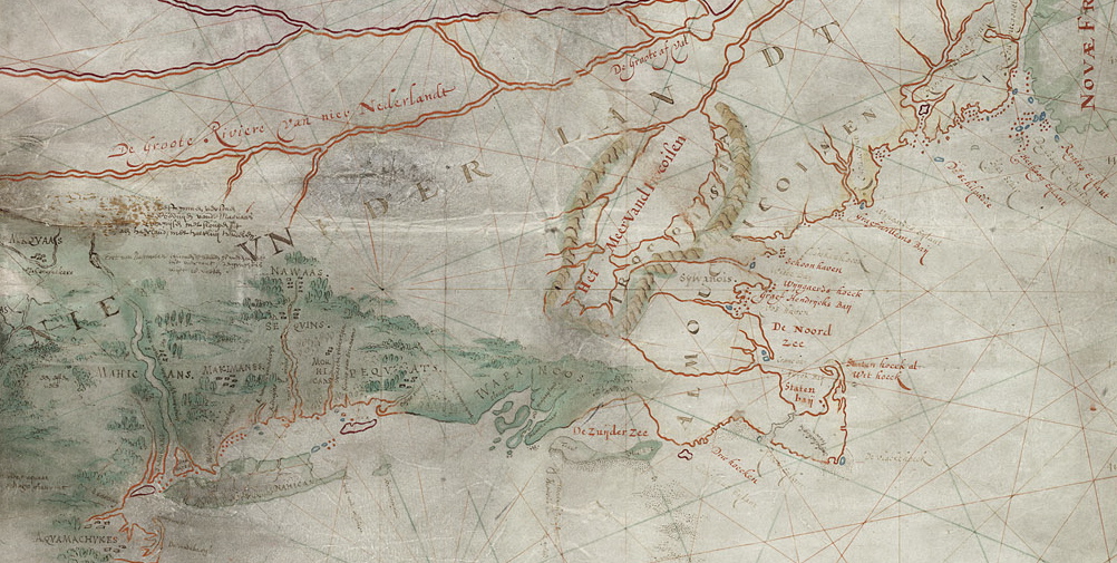
Oldest map of Manhattan
The map released by Adriaen Block in 1614 documented the area between the French territory of Nova Francia and the English territory of Virginia. It is considered the first detailed map of New Netherland as well as the middle portion of North East America. In addition, the map is considered the first document to use the name “New Netherland” (New Netherland). There is a theory which states that Block’s map is based on a map drawn by the cartographer Cornelius Doetz (the red lines), upon which he added his detailed discoveries. Though not entirely original, Block’s map is, nevertheless, considered the first detailed map of New York and North Eastern America, and the first to mention the island of Manhattan.
Many aspects of this map have yet to be investigated in detail, including the precise date of its creation. It is quite possible that this map was created in 1612 or 1613 and was used for a presentation to Prince Maurits. The map was found by John Romeyn Brodhead, an American who, in the nineteenth-century, visited the archives in London, Paris and Amsterdam in search of documents containing information about the history of New York. Brodhead discovered a wealth of new information that called previous assumptions into question. Suddenly the history of New York included New Netherland and the Dutch, not just the English, which had considerable consequences for Anglo-American historians who were looking to further strengthen the mythologies of Hudson, the Pilgrims, and Jamestown.